The Mount Triglav hike seems to be a must during a stay in Slovenia. You want to climb Mount Triglav but like us, you do not have 2 or 3 days for this? Or maybe it’s still to cold to climb the Slovenia’s highest peak (2864m) in Triglav National Park?
If you look for an other wonderful slovenian moutain trail, we advise you an alternative hike in the south of the Triglav Park. This easier option really made us live an unforgettable moment. Landscapes are breathtaking. One of the best self-guided hikes in Slovenia.
A great hike with a Slovenian friend, Alek, whom we had the chance to meet on the 1st day of our arrival in Slovenia. In the city of Tolmin, along the Soča river! The Soča river is translucent and has one of the more beautiful blue/green we have never seen… (we talk about it in our next article).
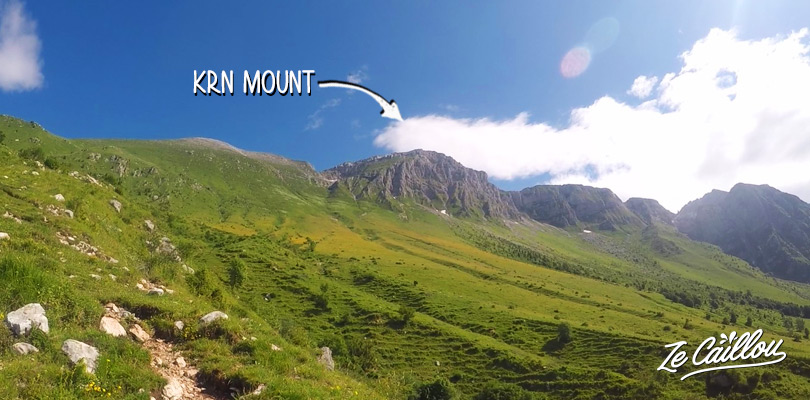
In short, the hike he made us discover is the ascent of Mount KRN (pronounced Kuran). It is the highest peak in the region (2244m), in the south of Triglav national park. And the views are worth almost as much as for Mount Triglav trek. You’ll find all the information about Mount KRN hike further down the article.
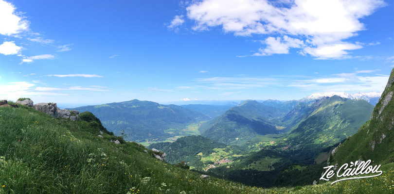
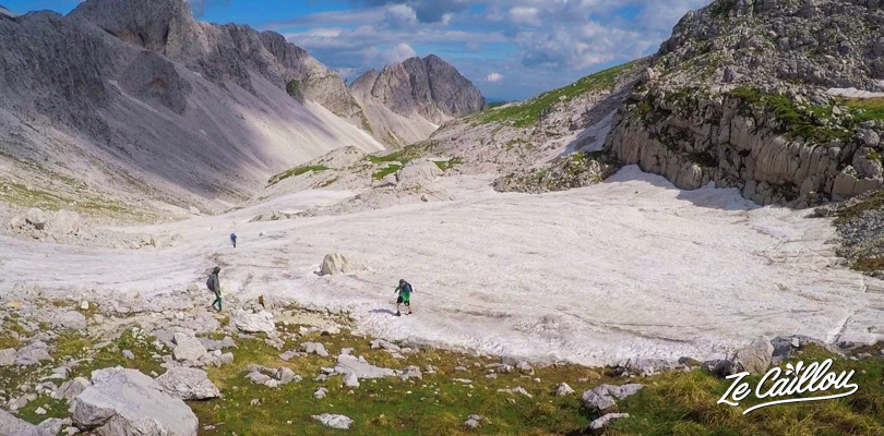
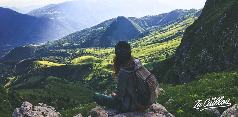
Plains, mountains, lakes and snow-capped peaks (even mid-June) where sheep and cows are having fun. Certainly one of the best walks in Slovenia.
At the top, it’s another world …
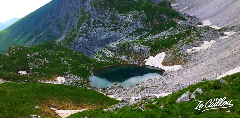
A breathtaking landscape! Camaïeu of blue, green, gray and white … snow-capped peaks and deep blue glacier lake below (KRN lake).
A great option for Mount Triglav, Mount KRN
1 – How to get to the hiking starting point
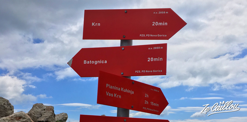
You can reach the starting point of Mount KRN hike by car from Kobarid or Tolmin cities. It’s a parking above the small KRN village, on the Planina Kuhinja in the south of the Triglav National Park.
Beware the road is narrow and with many zigzag (but not in poor condition).
>> Approximately 19 km and about 1/2 hour from Tolmin to the parking.
Note that someone just told us that the parking became a paid parking with a barrier at which you have to pay with a bank card with contactless payment.
2 – Mount KRN hiking trails
2.1) Return trip: Parking <> Mt KRN summit:
From the parking to the Mount KRN and same return (see on our map below).
- Duration: 2h30 (go up) ~ 4h/4h30 return trip
- Distance: 5,1km passing by the moutain refuge ~ 10km return trip
- Difference in altitude: 1200m of elevation gain one way.
- Marks: round red and white and some arrows indicate the path.
- No water, think to take enough water.
2.2) Loop: Parking > Mont KRN > Mont Batognica > Luznici Jezero (lake) > Parking
All the blue loop on the map below.
The hike from the parking to the top of Mount KRN is already wonderful, probably as much as Mount Triglav. But personally, we advise you to make the loop.
Landscapes are changing. After the summit, we pass by some rocky peaks, cross some snowy places, a reddish mountain, a crystalline dark blue lake…
- Duration: ~ 5 to 6h
- Distance: 13,3 km
- Difference in altitude: 1200m of elevation up to the Mount KRN summit, then again 100 to 200m. After, it’s just down to the parking.
- Marks: round red and white and some arrows indicate the path.
- There was a water point almost 740m after the Batognica summit, but it was dry when we went there.
Our hiking map for Mount KRN in the Triglav national park:
3 – Mount KRN hiking details
Mount KRN, a great option to Mount Triglav climbing in Slovenia.
Start and climbing up to the Mount KRN
There is a good vertical drop and it can be hot. So as for any hike, do not forget to take good shoes, sunscreen and 2L of water per person.
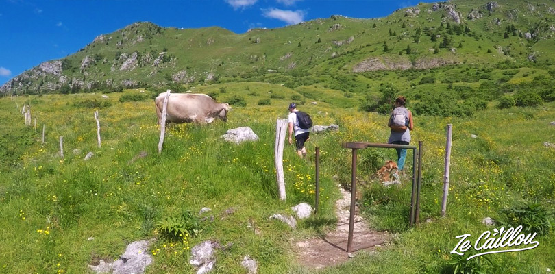
Once at the parking, go on your left (when watching the moutain), then follow the marks up to the moutain refuge.
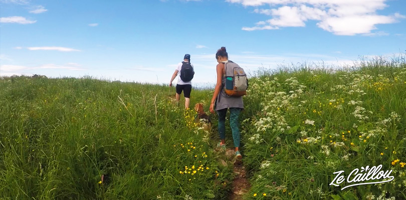
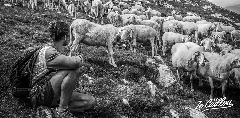
We’ll cross Planina Slapnik and Zaslap’s plains. Sheeps and cows are the masters of the place, be careful to keep the few small gates closed after your passage.
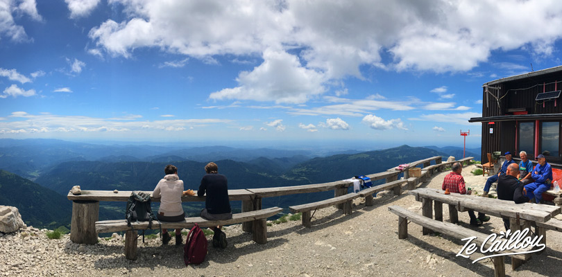
Sometimes the path isn’t really well indicated. But look at the refuge, the only “house” on the top on Mount KRN. Once there, you already have a really good view (on the side you just climbed), and many stop here to have a break. But there is just 10 minutes left to walk to the summit!
Mount KRN, a rich story for slovenians
Just for information – On your way, you’ll see barbed wire, rusty tin cans and maybe even gun bullets. All this dates from exactly 1 century this year, because they are the remains of the end of the 1st World War… and a hard battle against the Italians at the time when they were allied with Germany.
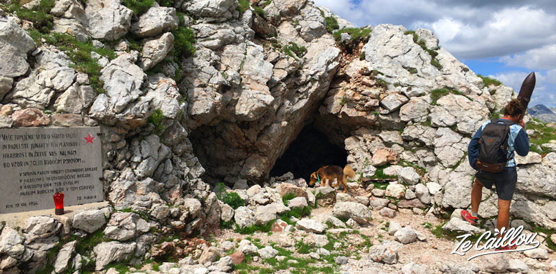
Slovenians we met are quite attached to their history and you can find many remains, bunkers and museums dedicated to the IWW in this region of Slovenia. By the way, we advise you the superb 5km”historical trail” of Kobarid (more info about it in our article “Roadtrip in Slovenia”).
Back to the hike, let’s climb Mount KRN
Here we are… after this last 10 minutes, the summit is here for you. Enjoy the view, it’s magic.
To tell the truth, we didn’t know how beautiful it was going to be!
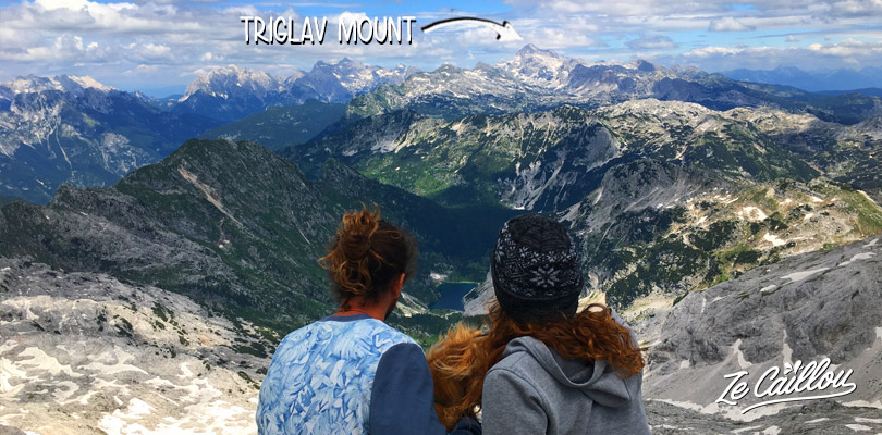
A breathtaking view on the Krnsko Jezero… surrounded by green and grey mountains,snowy summits… you can even see the Mount Triglav if you’re lucky.
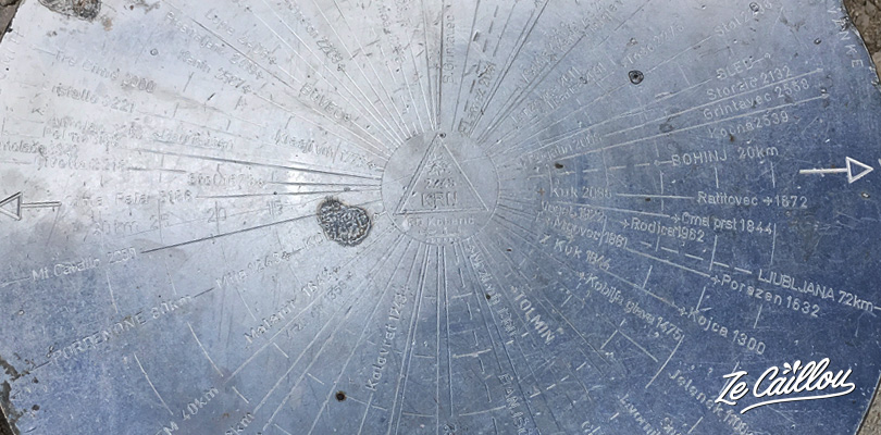
An iron plate indicates the name and direction of the different summits and surrounding towns. Bohinj, 20km. Ljubljana, 72km…
>> If you walk the return trip (parking<>summit), you know the way back!
>> If you choose the loop, there is still a good path to follow.
- About 8.2km to the parking
- With almost 1300m of altitude difference (only 100 in positive, then you’ll just have to go down).
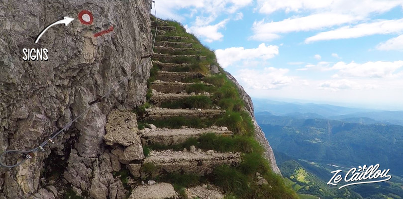
- Climb stone stairs, cross a deep blue lake, bypass a red mountain…
Au sommet, au lieu de repartir en arrière, continuez, vous verrez une descente. Puis une remontée vers le sommet Batognica (2164m). Avec des traces de la guerre (obus et plaques commémoratives), quelques panneaux indicatifs et un escalier en pierre qui longe un flanc de falaise (moins impressionnant en vrai).
At the top, instead of going back, continue on your right (when watching the lake). You will see a descent. You’ll then have to climb to the Batognica summit (2164m). You’ll cross some traces of the war (shells and commemorative tablets), some indicative marks and a stone stairs that runs along a cliff side (not to impressive in real life).
After Batognica summit, continue 2.2km following the marks and you will see Luznici Jezero (the lake) on your right. A great stop. Mid-June we had to go through some snowy places (+ 1m of snow). It was slippery sometimes but nothing bad and our dog was over the moon!
Last kilometers, the descent to the parking
After the lake, continue for about 900m and turn right to start the descent to the car park. You will see a beautiful red mountain on your left… again a new landscape!
It now remains 4.1km to the parking down the plains “Planina Leskovca and Kasina”. A landscape made us think of Machu Pichu, good memories! Or even to the Cirque de Mafate in Reunion Island.
Crossing beautiful plains, you’ll certainly see groundhogs, sheeps, chamois...
Then, the path go through grassy paths (beware of stinging nettles), and even some muddy passages where the ground was returned by wild pigs… Near the end, bypass a small house/farm on the right and follow the path that will take you through a beautiful plain directly to the parking lot.
>> We wish you a great hike!
This is the end, we hope this article made you want to climb Mount KRN. For us a wonderful alternative to the more well-known Mount Triglav, in the only National Park of Slovenia.
You plan to visit this amazing country? Read our article about the best spots in Slovenia.
If you like this article or if it is useful to you, do not hesitate to write us a comment or subscribe to our travel blog to receive our next articles.
Hi
Can you recommend a map for Krn area of the Julian Alps? I’m going to stay in the Lepena area and thought I had bought a hiking map but the maps on offer cover just a little bit too far north.
Sarah
Hi Sarah, no infortunately we don’t have a map we could recommend in mind… just for your info, we’ve just updated the article because the parking became a paid parking.
[…] He made us discover another hike that is well worth the detour. We liked it so much that we wrote an article about it in our travel blog. Besides, Slovenia is a Great country for hikers, so do not […]